Odemira
Odemira | |
|---|---|
 | |
 | |
| Coordinates: 37°35′N 8°38′W / 37.583°N 8.633°W | |
| Country | |
| Region | Alentejo |
| Intermunic. comm. | Alentejo Litoral |
| District | Beja |
| Parishes | 13 |
| Government | |
| • President | Hélder António Guerreiro (PS) |
| Area | |
• Total | 1,720.60 km2 (664.33 sq mi) |
| Population (2021) | |
• Total | 29,538 |
| • Density | 17/km2 (44/sq mi) |
| Time zone | UTC+00:00 (WET) |
| • Summer (DST) | UTC+01:00 (WEST) |
| Local holiday | 8 September |
| Website | www |
Odemira (pronounced [ɔðɨˈmiɾɐ] ) is a town and a municipality in Beja District in the Portuguese region of Alentejo. The population in 2021 was 29,538,[1] in an area of 1,720.6 square kilometres (664.3 sq mi), making it the largest municipality of Portugal by area.[2]
It is famous for its wild beaches and for being home to a significant Dutch and German community. The village of Zambujeira do Mar is home to the Festival do Sudoeste, one of the biggest rock festivals in Europe.
The municipality of Odemira has great agricultural potential, specially in the western area of the region, and is home to major operations of important agricultural companies like Vitacress.
The present Mayor is Hélder António Guerreiro, elected by the Socialist Party in 2021. The municipal holiday is 8 September.
History
[edit]The region has been inhabited since ancient times, as evidenced by archaeological remains predating the Roman era. Successive civilizations, including the Romans and later the Muslim states of Al-Andalus, left their mark on the local culture and traditions.[3]
During the Islamic period, the area gained prominence, with the name "Odemira" potentially originating from the Arabic word wad (river) combined with the pre-Celtic term mira, also associated with water. According to legend, the name stems from a warning issued by a Moorish woman in the castle: "Ode, mira para os inimigos!" ("Ode, look at the enemies!").[3]
The Christian reconquest of Odemira occurred relatively late, possibly carried out by the Order of Santiago. By 1238, the region was under Christian control. In 1245, the castle of Odemira was donated by Paio Peres Correia, Master of the Order of Santiago, to the Bishop of Porto, Pedro Salvadores.[3]
On 28 March 1256, King Afonso III incorporated Odemira into the Crown and granted it a municipal charter (foral). This charter delineated the boundaries of the municipality and reflected a continuity of administrative practices from the Islamic period. Positioned near the navigable stretch of the Mira River, Odemira became a central hub for a vast surrounding territory, following a territorial model common to many southwestern Iberian settlements.[3]
Under King Dinis, the lordship of Odemira was granted to Manuel Pessanha in 1319, a Genoese admiral instrumental in organizing the Portuguese navy. During the reign of King Afonso IV, Odemira briefly returned to the Order of Santiago before being reincorporated into the Crown in 1352.[3]
In 1357, the castle briefly returns to the Pessanha family, when King Pedro I gave it to Lançarote Pessanha. In 1387, King João I transferred the lordship of Odemira to Lourenço Anes Fogaça, whose descendants maintained control until the late 15th century. In 1446, King Afonso V created the title of Count of Odemira, bestowing it upon Sancho de Noronha.[3]
Odemira received a new foral from King Manuel I in 1510 as part of the widespread administrative reforms of the time. This document emphasized the economic importance of maritime trade, livestock, and local mineral resources.[3]
The title of Count of Odemira became extinct in 1661 when the holdings were incorporated into the House of Cadaval. During the 19th century, liberal reforms redefined the municipality's boundaries, giving it its present configuration.[3]
In 1888, the Linha do Sul railway line reached the Odemira municipality, connecting it to Setúbal and Lisbon to the north and a year later to Algarve to the south. While it did not reach the town of Odemira, three stations were constructed in the east of the municipality: Amoreiras-Odemira in São Martinho das Amoreiras, Luzianes and Santa Clara - Saboia, near the villages of Santa Clara-a-Velha and Sabóia. The arrival of the railways permitted the creation of small population centers around these stations.[4] The station in Luzianes was deactivated in 2012, due to low demand.[5]
Geography
[edit]
The municipality of Odemira is located in southwestern Portugal, bordered by the municipalities of Sines and Santiago do Cacém to the north, Ourique to the east, and the Algarvian municipalities of Aljezur and Monchique to the south.
Much of the municipality is within the Southwest Alentejo and Vicentine Coast Nature Park.
Climate
[edit]Odemira has a Mediterranean climate. Winters are mild and rainy, with daytime temperatures usually around 16 °C (61 °F) and nighttime lows around 6 °C (43 °F). Summers are dry and sunny and are hot in the interior of the municipality (maxima is around 31 °C (88 °F) bordering Ourique) and warm at the coast (where maxima is around 25 °C (77 °F)).[6]
| Climate data for Relíquias, 1980-2010, altitude: 244 m (801 ft) | |||||||||||||
|---|---|---|---|---|---|---|---|---|---|---|---|---|---|
| Month | Jan | Feb | Mar | Apr | May | Jun | Jul | Aug | Sep | Oct | Nov | Dec | Year |
| Average precipitation mm (inches) | 57.1 (2.25) |
58.6 (2.31) |
46.0 (1.81) |
54.1 (2.13) |
33.4 (1.31) |
10.5 (0.41) |
2.0 (0.08) |
4.8 (0.19) |
19.2 (0.76) |
80.4 (3.17) |
86.4 (3.40) |
79.1 (3.11) |
531.6 (20.93) |
| Source: Portuguese Environment Agency[7] | |||||||||||||
Parishes
[edit]Administratively, the municipality is divided into 13 civil parishes (freguesias):[8]
- Boavista dos Pinheiros
- Colos
- Longueira / Almograve
- Luzianes-Gare
- Relíquias
- Sabóia
- Santa Clara-a-Velha
- São Luís
- São Martinho das Amoreiras
- São Salvador e Santa Maria
- São Teotónio
- Vale de Santiago
- Vila Nova de Milfontes
Transports
[edit]There are two active railway stations in the Odemira municipality in the Linha do Sul railway line: Amoreiras-Odemira in São Martinho das Amoreiras and Santa Clara - Saboia nearby the villages of Santa Clara-a-Velha and Sabóia.[4] Neither of these stations passes by the town of Odemira, with the Amoreiras-Odemira station located 22.8 kilometres (14.2 mi) northeast of the town of Odemira.
Notable people
[edit]- Pedro Damiano (1480–1544) a Portuguese chess player and pharmacist by profession
- Jéssica Silva (born 1994) a footballer
- Pedro de Almada Pereira (1835 in Odemira – 1911) a landowner, schoolmaster and journalist, founder of the periodical O Campo de Ourique
Population
[edit]| Odemira Municipality's population (1801–2021) | |||||||||||||||||
|---|---|---|---|---|---|---|---|---|---|---|---|---|---|---|---|---|---|
| 1801 | 1849 | 1864 | 1878 | 1890 | 1900 | 1911 | 1920 | 1930 | 1940 | 1950 | 1960 | 1970 | 1981 | 1991 | 2001 | 2011 | 2021 |
| 6,390 | 11,669 | 17,136 | 18,098 | 19,386 | 20,489 | 23,883 | 27,697 | 32,541 | 40,513 | 44,050 | 43,999 | 33,235 | 29,463 | 26,418 | 26,106 | 26,066 | 29,538 |
| Source: INE[1][9][10][11][12][13] | |||||||||||||||||
Gallery
[edit]-
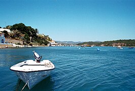
Vila Nova de Milfontes.
-
Vila Nova de Milfontes.
-
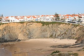
Zambujeira.
References
[edit]- ^ a b INE (2021). "Censos". Instituto Nacional de Estatística. Retrieved 22 November 2024.
- ^ "Áreas das freguesias, concelhos, distritos e país". Archived from the original on 5 November 2018. Retrieved 5 November 2018.
- ^ a b c d e f g h "História" [History]. Câmera Municipal de Odemira (in European Portuguese). Retrieved 24 November 2024.
- ^ a b Alves, Rui Manuel Vaz (11 November 2015). Arquitetura, Cidade e Caminho de Ferro: as transformações urbanas planeadas sob a influência do caminho de ferro (PhD thesis). p. 288 - 295.
- ^ Ferreira, Bianca Castro, Joana Vasquez (9 March 2021). "Luzianes: onde os comboios passam, mas não param". PÚBLICO (in Portuguese). Retrieved 24 November 2024.
{{cite web}}: CS1 maint: multiple names: authors list (link) - ^ "Monotorização Diária". IPMA. Retrieved 8 January 2022.
- ^ "Monthly Precipitation Relíquias". APA. Retrieved 4 June 2021.
- ^ Diário da República. "Law nr. 11-A/2013, pages 552 81-82" (PDF) (in Portuguese). Retrieved 29 July 2014.
- ^ INE (2001). "Censos". Instituto Nacional de Estatística. Retrieved 22 November 2024.
- ^ INE (1996). "Região do Alentejo". Censos 1991. XIII Recenseamento Geral da População. III Recenseamento Geral da Habitação. Resultados definitivos [Census 1991. XIII General Population Census. III General Housing Census. Definitive results.] (in European Portuguese). Lisbon. p. 16. Retrieved 22 November 2024.
{{cite book}}: CS1 maint: location missing publisher (link) - ^ INE (1984). "Distrito de Beja". XII Recenseamento Geral da População. II Recenseamento Geral da Habitação. Resultados definitivos: 1981 [XII General Population Census. II General Housing Census. Definitive Results: 1981] (in European Portuguese). Lisbon. p. 3. Retrieved 22 November 2024.
{{cite book}}: CS1 maint: location missing publisher (link) - ^ INE (1971). "1º Volume". 11º Recenseamento da População. 1º Recenseamento da Habitação: continente e ilhas: 1970 [11th Population Census. 1st Housing Census: mainland and islands: 1970] (in European Portuguese). Lisbon. p. 6. Retrieved 22 November 2024.
{{cite book}}: CS1 maint: location missing publisher (link) - ^ INE (1964). "Tomo I Volume 1º". X Recenseamento Geral da População no continente e ilhas adjacentes às 0 horas de 15 de Dezembro de 1960 [10th General Population Census in the mainland and adjacent islands as of 12:00 AM on December 15, 1960] (in European Portuguese). Lisbon. p. 18. Retrieved 22 November 2024.
{{cite book}}: CS1 maint: location missing publisher (link)
External links
[edit]


